The Cheyenne Office of the National Weather Service is predicting a "roller coaster" of weather over the next few days, including possibly severe weather this weekend.

The agency posted the following on it's Facebook page;

A roller coaster weather pattern will take shape Friday through Tuesday, with Friday seeing critical fire danger with very warm temperatures and widespread snowfall returning Monday. Saturday and Sunday both have the threat for severe weather, with a Slight Risk (Level 2 of 5) for severe weather in place both days. A very strong cold front moves through Sunday into Monday, with rain changing to rain/snow then widespread snow throughout the morning hours. Snow and rain come to an end Tuesday, then a slow warming trend starts. Buckle up!

So what about the possibly severe weather this weekend?

The threat for a few severe thunderstorms exists this weekend east of the I-25 corridor into Western Nebraska. Large hail and damaging winds appear to be the primary hazards.

Imaging showing the location of the severe thunderstorm threat into this weekend across Eastern Wyoming and Western Nebraska
Cheyenne, Laramie Forecasts
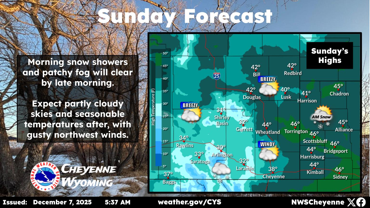
Cheyenne Forecast

Tonight
Mostly cloudy, with a low around 50. West northwest wind 10 to 15 mph decreasing to 5 to 10 mph in the evening. Winds could gust as high as 25 mph.
Saturday
A 40 percent chance of showers and thunderstorms, mainly after 3pm. Mostly sunny, with a high near 73. Breezy, with a west northwest wind 5 to 10 mph becoming south 15 to 20 mph in the morning. Winds could gust as high as 30 mph.
Saturday Night
A chance of showers and thunderstorms. Partly cloudy, with a low around 47. South southeast wind 5 to 15 mph becoming northwest after midnight. Winds could gust as high as 25 mph. Chance of precipitation is 40%.
Sunday
Showers likely and possibly a thunderstorm after noon. Partly sunny, with a high near 63. West northwest wind 10 to 15 mph becoming north in the afternoon. Winds could gust as high as 25 mph. Chance of precipitation is 60%.
Sunday Night
Rain showers before midnight, then rain and snow showers. Some thunder is also possible. Low around 31. North northeast wind 10 to 15 mph. Chance of precipitation is 100%.
Monday
Snow showers, possibly mixed with rain, becoming all snow after noon. Some thunder is also possible. High near 38. Breezy. Chance of precipitation is 100%.
Monday Night
A slight chance of rain and snow showers before 9pm, then a slight chance of snow showers between 9pm and midnight. Partly cloudy, with a low around 24. Blustery. Chance of precipitation is 20%.
Tuesday
A slight chance of showers and thunderstorms after noon. Mostly sunny, with a high near 50.
Tuesday Night
A chance of showers, mainly before midnight. Mostly cloudy, with a low around 30.
Wednesday
A slight chance of showers and thunderstorms after noon. Mostly sunny, with a high near 59.
Wednesday Night
A slight chance of showers. Partly cloudy, with a low around 36.
Thursday
A slight chance of showers and thunderstorms. Mostly sunny, with a high near 66.
Thursday Night
A slight chance of showers and thunderstorms. Partly cloudy, with a low around 40.
Friday
A slight chance of showers and thunderstorms. Mostly sunny, with a high near 72.
Laramie Forecast
Tonight
Mostly cloudy, with a low around 47. Breezy, with a west wind 15 to 25 mph becoming west southwest 5 to 10 mph after midnight. Winds could gust as high as 35 mph.
Saturday
A 50 percent chance of showers and thunderstorms after noon. Mostly sunny, with a high near 67. South southwest wind 10 to 15 mph.
Saturday Night
A chance of showers and thunderstorms. Mostly cloudy, with a low around 41. South wind 10 to 15 mph becoming northwest after midnight. Chance of precipitation is 50%.
Sunday
A chance of showers, then showers likely and possibly a thunderstorm after noon. Partly sunny, with a high near 56. West wind 10 to 15 mph becoming east northeast in the afternoon. Chance of precipitation is 70%.
Sunday Night
Rain and snow showers, becoming all snow after 3am. Some thunder is also possible. Low around 30. East northeast wind 10 to 15 mph. Chance of precipitation is 100%.
Monday
Snow showers. Some thunder is also possible. High near 33. Breezy. Chance of precipitation is 100%.
Monday Night
A 30 percent chance of snow showers, mainly before midnight. Mostly cloudy, with a low around 20.
Tuesday
A slight chance of snow showers after noon. Some thunder is also possible. Mostly sunny, with a high near 43.
Tuesday Night
A slight chance of snow showers before midnight. Mostly cloudy, with a low around 27.
Wednesday
Mostly sunny, with a high near 53.
Wednesday Night
A slight chance of showers. Partly cloudy, with a low around 34.
Thursday
A slight chance of showers and thunderstorms. Mostly sunny, with a high near 61.
Thursday Night
Partly cloudy, with a low around 39.
Friday
Mostly sunny, with a high near 67.

Medicine Bow Wyoming Road Art

There’s a strange mind at work in Medicine Bow. Someone equal parts disturbed and delighted, scheming and laughing at the same time. And somehow, they want to pull you into the fun.

Gallery Credit: Glenn Woods


More From KGAB