

Flood Watch Issued For Almost All Of Southeast Wyoming
The Cheyenne Office of the National Weather Service has issued a flood watch for southeast Wyoming.
The watch includes the green area on the map below
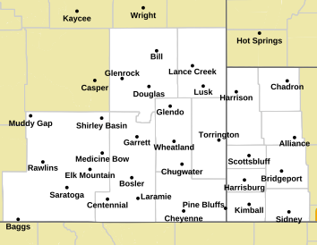
According to the agency:
● The FLOOD WATCH goes into effect today at Noon for the Southeast Wy area and 6PM for the Nebraska Panhandle. ○ Main Impacts for areas West of I-25 is going to be mainly excessive runoff from terrain pooling in low lying areas.
■ Streams and rivers are fairly low so no flooding impacts are expected but the water level may rise within banks. ○ Areas East of I-25 is going to be mainly from training of strong thunderstorms and hydrophobic soils.
■ Flat Farmland may having standing water from training thunderstorms ● Canals and ditches may become full
● Urban Areas may see temporary backup of drainage areas leading to flooded roadways and underpasses
Forecasts for Cheyenne, Laramie
Cheyenne Forecast
🌷 10 Colorful Things to Grow in your Zone 5 Garden
Gallery Credit: Kolby Fedore, Townsquare Media
More From KGAB