Dangerously cold weather ranging into the minus double digits and wind chills dipping below -30 or colder in many areas are in the SE Wyoming weather forecast through Monday.

That's according to the Cheyenne Office of the National Weather Service. The agency posted the following on its website:

Here's a look at forecast wind chill temperatures for a handful of locations across our area. Dangerous cold is expected for our area in two surges: the first occurring during the day Friday, and the second occurring Sunday night or Monday, which will spread cold to higher elevations west of the Laramie range. Wind Chill Warnings are in effect for all areas along and east of the Laramie range 5PM Friday through 6AM Monday.

And besides the brutally cold temperatures, snow squalls are also in the forecast:

Friday's arctic cold front will also come with another round of snow. Expect snow showers to redevelop over Wyoming Fri morning and spread eastward through the afternoon and evening. Briefly intense snow squalls are also possible, and may bring locally heavy snow, visibility under 1/4 mile, and gusty winds.

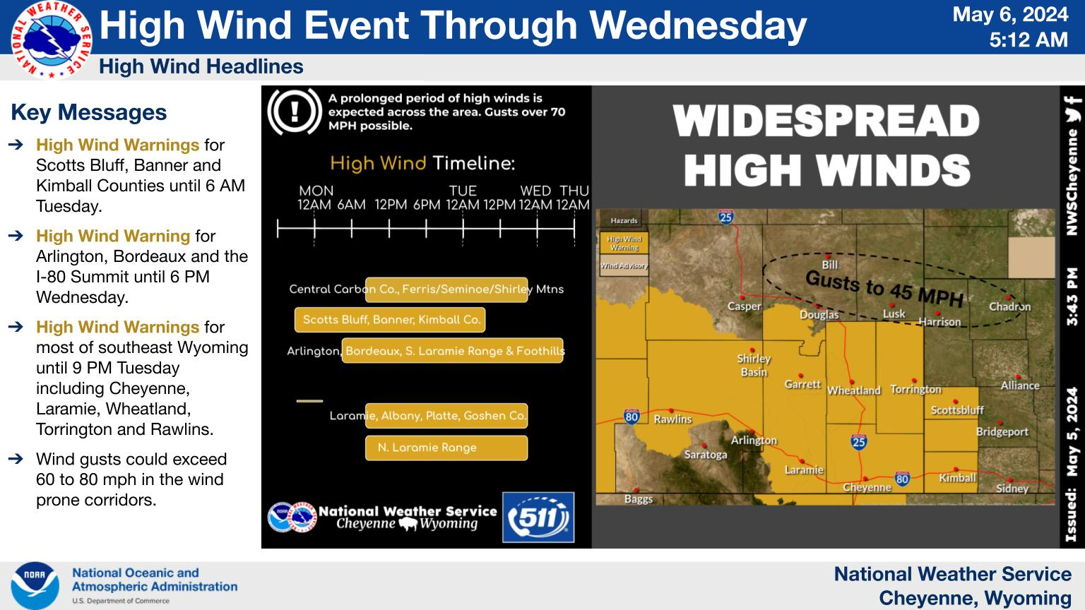
As if that wasn't enough, both Cheyenne and Laramie are also under high-wind warnings:

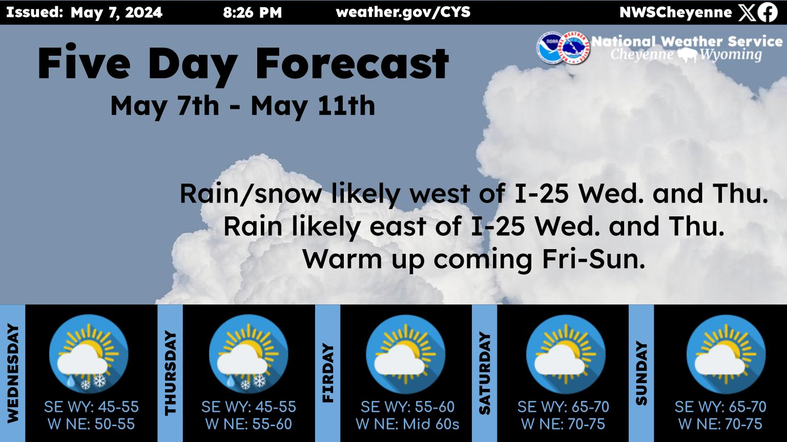
Here is the forecast for Cheyenne and Laramie

Cheyenne forecast:

Today
A 40 percent chance of snow showers, mainly after 11am. Patchy blowing snow after 5pm. Partly sunny, with a temperature rising to near 23 by noon, then falling to around 9 during the remainder of the day. Wind chill values between -10 and zero. Windy, with a west wind 20 to 25 mph becoming west 25 to 30 mph in the afternoon. Winds could gust as high as 40 mph.
Tonight
Snow showers likely, mainly before 11pm. Patchy blowing snow between 7pm and 10pm. Mostly cloudy, with a low around -19. Wind chill values between -30 and -40. North wind around 15 mph. Chance of precipitation is 60%. New snow accumulation of around an inch possible.
Saturday
A 40 percent chance of snow showers. Mostly sunny and cold, with a high near -3. Wind chill values between -30 and -40. North northwest wind 10 to 15 mph.
Saturday Night
A 40 percent chance of snow showers. Mostly cloudy, with a low around -15. Wind chill values between -25 and -30. East wind 5 to 10 mph becoming south in the evening.
Sunday
Snow showers likely, mainly before 11am. Mostly cloudy and cold, with a high near 0. South wind 5 to 10 mph. Chance of precipitation is 70%.
Sunday Night
Snow showers. Low around -15. Chance of precipitation is 80%.
M.L.King Day
Snow showers likely, mainly before 11am. Partly sunny and cold, with a high near -3. Chance of precipitation is 60%.
Monday Night
Mostly clear, with a low around -15. Breezy.
Tuesday
Mostly sunny, with a high near 26. Breezy.
Tuesday Night
Partly cloudy, with a low around 16. Breezy.
Wednesday
A slight chance of snow showers. Mostly sunny, with a high near 38. Breezy.
Wednesday Night
A slight chance of snow showers. Mostly cloudy, with a low around 17. Breezy.
Thursday
A slight chance of snow showers. Partly sunny, with a high near 32. Breezy.
Laramie forecast:
Today
Snow showers likely, mainly after 11am. Patchy blowing snow after 11am. Partly sunny, with a high near 17. Wind chill values between -5 and -15. Windy, with a west wind 15 to 20 mph increasing to 25 to 30 mph in the afternoon. Winds could gust as high as 45 mph. Chance of precipitation is 60%. Total daytime snow accumulation of less than one inch possible.
Tonight
Snow showers likely. Patchy blowing snow before 8pm. Mostly cloudy, with a low around -13. Wind chill values between -20 and -30. Blustery, with a northwest wind 10 to 20 mph. Chance of precipitation is 70%. New snow accumulation of less than one inch possible.
Saturday
A 40 percent chance of snow showers. Patchy blowing snow between 1pm and 3pm. Mostly sunny and cold, with a high near 3. Wind chill values between -25 and -35. Blustery, with a northwest wind 10 to 20 mph, with gusts as high as 30 mph.
Saturday Night
A 50 percent chance of snow showers. Increasing clouds, with a low around -9. Wind chill values between -10 and -15. Northwest wind 5 to 10 mph becoming southeast after midnight.
Sunday
Snow showers. High near 10. South southeast wind around 5 mph becoming northwest in the afternoon. Chance of precipitation is 80%.
Sunday Night
Snow showers. Low around -10. Chance of precipitation is 90%.
M.L.King Day
Snow showers likely, mainly before 11am. Partly sunny and cold, with a high near -4. Chance of precipitation is 60%.
Monday Night
Mostly clear, with a low around -20.

Must Read Books From Wyoming Authors

Gallery Credit: Glenn Woods


More From KGAB