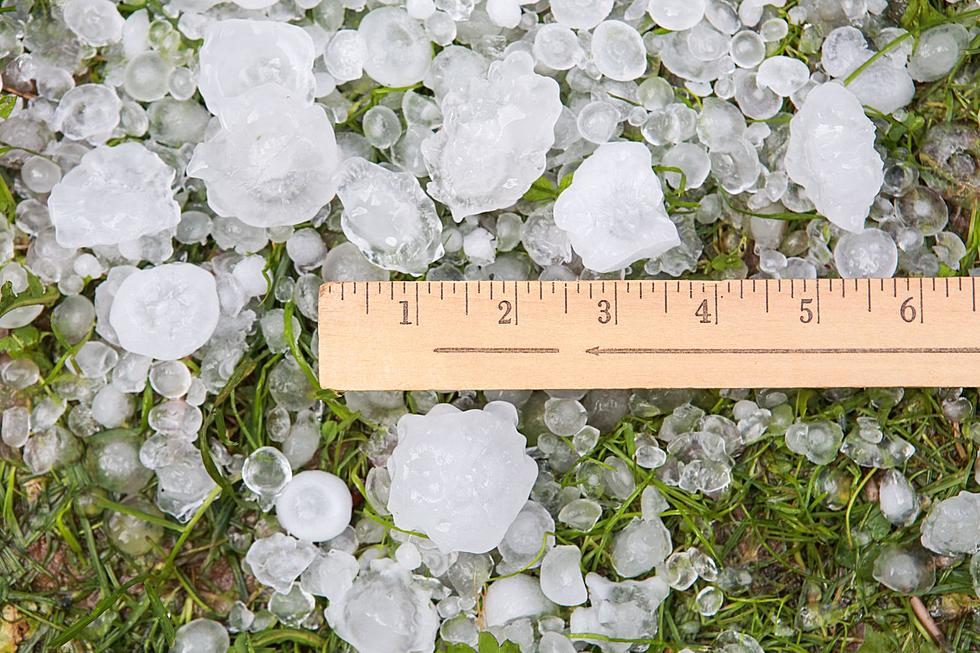
Severe Storms, Hail Possible In SE Wyoming, Tornado Not Ruled Out
The Cheyenne Office of the National Weather Service says strong to severe storms are possible in southeast Wyoming today (June 8).
The storms could feature strong winds and/or large hail. While a tornado is unlikely, the agency says that possibility "can't be ruled out."
The agency posted the following on its website: ''Another round of showers and thunderstorms is expected today, with the potential to become strong to severe during the afternoon. The main area of concern is the I-80 corridor from Cheyenne to Sidney between noon and 5PM. The primary hazards today are strong winds and/or large hail. Tornadoes are unlikely, but can't be ruled out. Stay weather aware through the afternoon today!''
Cheyenne and Laramie Forecasts
Cheyenne Forecast
Today
Showers and thunderstorms likely, mainly after noon. Partly sunny, with a high near 71. East wind 10 to 15 mph becoming south in the afternoon. Chance of precipitation is 70%. New rainfall amounts between a half and three quarters of an inch possible.
Tonight
A 40 percent chance of showers and thunderstorms before midnight. Mostly cloudy, with a low around 52. South southwest wind 5 to 10 mph.
Sunday
Showers and thunderstorms likely after noon. Partly sunny, with a high near 72. Southwest wind 5 to 15 mph becoming southeast in the afternoon. Chance of precipitation is 60%.
Sunday Night
A 30 percent chance of showers and thunderstorms before midnight. Mostly cloudy, with a low around 52. South southeast wind 5 to 15 mph.
Monday
Showers likely and possibly a thunderstorm after noon. Mostly cloudy, with a high near 78. South wind 5 to 15 mph. Chance of precipitation is 60%.
Monday Night
A 30 percent chance of showers and thunderstorms before midnight. Mostly cloudy, with a low around 49.
Tuesday
A 20 percent chance of showers and thunderstorms after noon. Sunny, with a high near 79.
Tuesday Night
Mostly clear, with a low around 51.
Wednesday
Sunny, with a high near 88.
Wednesday Night
Partly cloudy, with a low around 55.
Thursday
A slight chance of showers and thunderstorms. Mostly sunny, with a high near 87.
Thursday Night
A slight chance of showers and thunderstorms. Partly cloudy, with a low around 53.
Friday
A chance of showers and thunderstorms. Mostly sunny, with a high near 85.
Laramie Forecast:
Today
Showers and thunderstorms likely, mainly after noon. Partly sunny, with a high near 68. West wind 10 to 15 mph. Chance of precipitation is 70%. New rainfall amounts between a tenth and quarter of an inch, except higher amounts possible in thunderstorms.
Tonight
A 40 percent chance of showers and thunderstorms before midnight. Partly cloudy, with a low around 50. West wind 10 to 15 mph becoming south in the evening.
Sunday
Showers and thunderstorms likely after noon. Mostly sunny, with a high near 66. Southwest wind 10 to 15 mph becoming east southeast in the morning. Chance of precipitation is 60%.
Sunday Night
A 30 percent chance of showers and thunderstorms before midnight. Mostly cloudy, with a low around 50. Southeast wind 10 to 15 mph becoming south southwest after midnight. Winds could gust as high as 25 mph.
Monday
Showers likely and possibly a thunderstorm after noon. Partly sunny, with a high near 71. West wind 10 to 15 mph. Chance of precipitation is 60%.
Monday Night
A 40 percent chance of showers and thunderstorms before midnight. Partly cloudy, with a low around 46.
Tuesday
A 20 percent chance of showers and thunderstorms after noon. Sunny, with a high near 71.
Tuesday Night
Mostly clear, with a low around 51.
Wednesday
Sunny, with a high near 77.
Wednesday Night
Partly cloudy, with a low around 53.
Thursday
A slight chance of showers and thunderstorms. Mostly sunny, with a high near 78.
Thursday Night
A slight chance of showers and thunderstorms. Partly cloudy, with a low around 53.
Friday
A chance of showers and thunderstorms. Mostly sunny, with a high near 75.
10 Rules Wyoming Drivers Refuse to Follow
More From KGAB