UPDATE 1:40 p.m. The Cheyenne Office of the National Weather Service has now updated the Winter Storm Watch that had been in effect for Cheyenne and much of southeast Wyoming to a more severe Winter Storm Warning. Laramie at last report was just outside of the area covered by the storm warning, although snow and cold temperatures are forecast for Laramie.

According to the National Weather Service, a Winter Storm Warning is Issued when hazardous winter weather in the form of heavy snow, heavy freezing rain, or heavy sleet is imminent or occurring. Winter Storm Warnings are usually issued 12 to 24 hours before the event is expected to begin

By contrast, a Winter Storm Watch: Alerts the public to the possibility of a blizzard, heavy snow, heavy freezing rain, or heavy sleet. Winter Storm Watches are usually issued 12 to 48 hours before the beginning of a Winter Storm

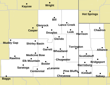
Here is a map of the area now covered by a Winter Storm Warning:

Map of Forecast Area

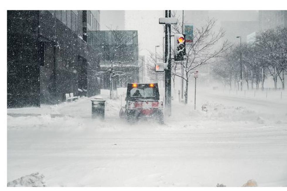
Original Post: The Cheyenne Office of the National Weather Service says up to 9 inches of snow are possible in low-lying areas of southeast Wyoming over the next couple of days.

Higher elevations could get up to 14 inches.

The agency posted the following on its website:

''A Winter Storm Watch is in effect from 11 AM Thursday through 11 PM Friday for Harrison, Bill, Douglas, Deer Creek, Glenrock, Luck, Redbird, Bordeaux, Wheatland, Guernsey, Torrington, Buford, Pumpkin Vine, Vedauwoo, Whitaker, Federal and Horse Creek. Heavy snow will be possible with accumulations of 5 to 9 inches possible. A Winter Storm Watch is in effect from 2 PM Thursday to 11 PM Friday for Chadron, Alliance, Hemingford, Scottsbluff, Harrisburg, Bridgeport, Cheyenne and Pine Bluffs. Heavy snow will be possible with accumulations of 4 to 8 inches. Gusty winds up to 40 mph will produce blowing snow and reduced visibilities. Wind chills will be at or below zero Friday and Friday night. For the North Laramie Range, snowfall totals of 8 to 14 inches will be possible. Travel could be very difficult to impossible.''


The agency says that Cheyenne will probably get at least six inches of snow, and there is a good chance that Laramie will:

May be an image of map and text that says '100% Percent Chance of 6" Snow or More Valid AM Thu Nov 23, 2023 through 11 AM Sat Nov 25, 2023 MST 25 90% EATHE EAT IssuedNc Weather Forecast Office Cheyenne, WY 22, 2023 1:16AMMST 80% () Nore o0 70% 81% Bill 60% 63% Casper 50% 84% Douglas 1 Of Carte Pertt 79% Lusk 40% 50% Chadron 74% Harrison 30% 20% 28% Rawlins 35% Shirley 77% Basin 80% 68% Garrett Wheatland Tgon59% Scottsbluff 47% Bridgeport 10% 53% Alliance 0% 28% Arlington Saratoga 34% Laramie f Baggs NWSCheyenne மசார 80 68% Cheyenne 43% Kimball 35% Sidney weather.gov/cys'

An information packet on the winter weather from the National Weather Service included the following Key Points:

Key Messages ➔ An incoming winter storm will bring widespread snowfall to southeast Wyoming and the Nebraska panhandle. ➔ Snow will begin during the day on Thursday and will continue through Friday. ➔ Much colder temperatures are expected with this system. Cold temperatures will persist Thursday through the weekend. ➔ Winter Storm Watches are in effect for portions of southeast Wyoming and western Nebraska. ◆ In effect from 11 AM Thursday through 11 PM Friday. ◆ Accumulations of 4 to 9 inches. ◆ North Laramie Range 8-12+ inches. ➔ The hazardous conditions could impact holiday travel. ➔ Winter Storm Watches may be expanded into other areas and/or upgraded in future forecast packages

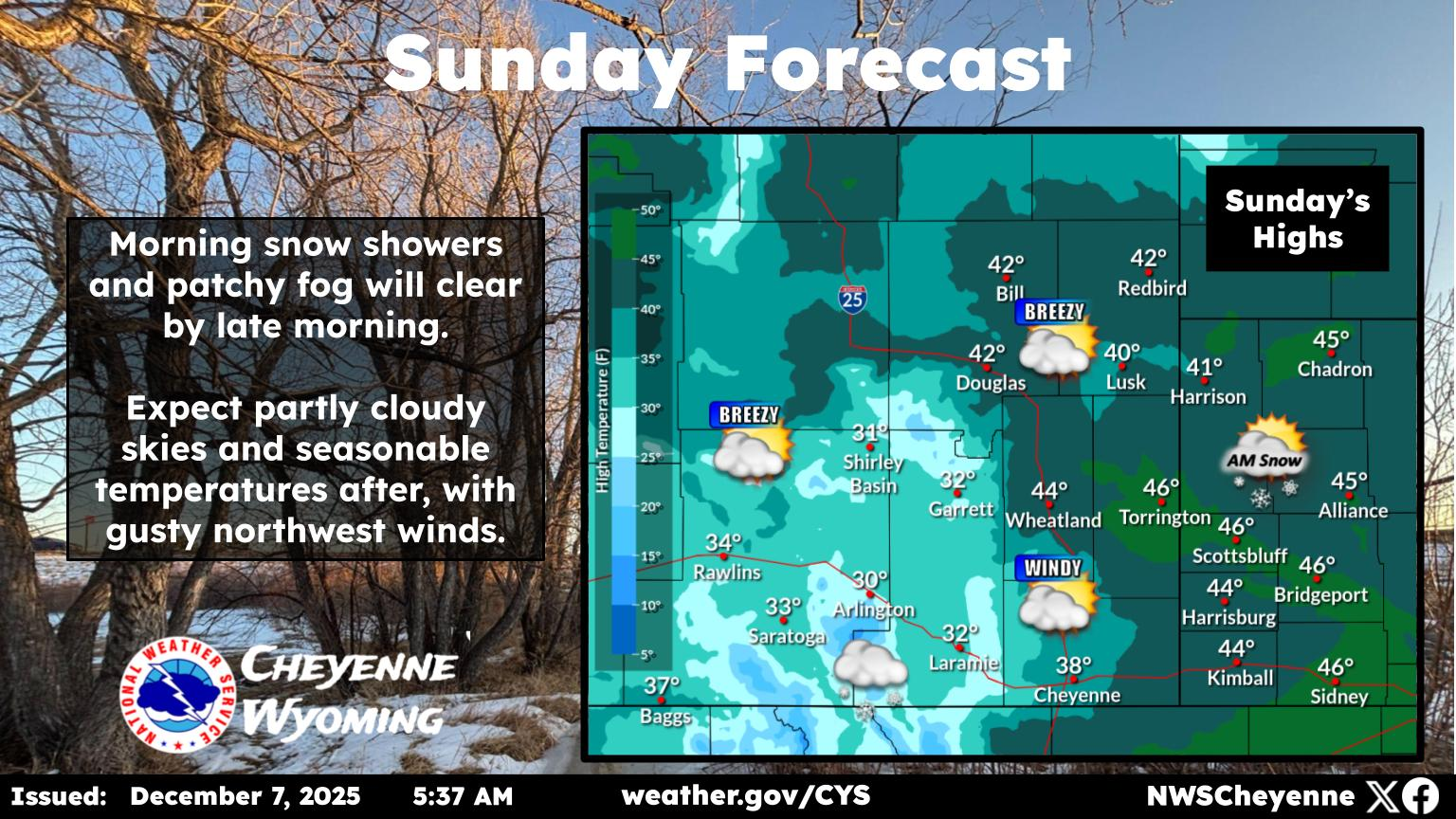
Here is the forecast for Cheyenne:

Today
Sunny, with a high near 65. Breezy, with a west wind 15 to 20 mph, with gusts as high as 30 mph.
Tonight
Mostly clear, with a low around 25. West northwest wind 5 to 10 mph.
Thanksgiving Day
A 40 percent chance of snow showers after 11am. Mostly cloudy, with a high near 34. East southeast wind 5 to 15 mph.
Thursday Night
Snow showers. Low around 10. Wind chill values between zero and 5. East wind around 15 mph. Chance of precipitation is 100%. New snow accumulation of 3 to 7 inches possible.
Friday
Snow showers. High near 15. Southeast wind around 15 mph. Chance of precipitation is 80%.
Friday Night
Snow showers likely, mainly before 11pm. Patchy fog after 5am. Otherwise, mostly cloudy, with a low around 6. Chance of precipitation is 60%.
Saturday
A 20 percent chance of snow before 11am. Partly sunny, with a high near 24.
Saturday Night
Mostly clear, with a low around 9.
Sunday
Sunny, with a high near 32.
Sunday Night
Mostly clear, with a low around 11.
Monday
Sunny, with a high near 39.
Monday Night
Mostly clear, with a low around 20.
Tuesday
Mostly sunny, with a high near 42. Breezy.
Here is the Laramie Forecast:
Today
Sunny, with a high near 53. Breezy, with a west wind 20 to 25 mph, with gusts as high as 35 mph.
Tonight
Partly cloudy, with a low around 24. West wind 5 to 15 mph.
Thanksgiving Day
A chance of flurries before 11am, then snow showers likely after 11am. Patchy blowing snow before 2pm, then patchy blowing snow after 3pm. Patchy fog after 5pm. Otherwise, mostly cloudy, with a temperature rising to near 26 by 11am, then falling to around 22 during the remainder of the day. Breezy, with an east southeast wind 10 to 15 mph increasing to 15 to 20 mph in the morning. Winds could gust as high as 30 mph. Chance of precipitation is 60%. New snow accumulation of 1 to 2 inches possible.
Thursday Night
Snow showers. Areas of blowing snow. Low around 7. Wind chill values between -10 and zero. Breezy, with an east wind 20 to 25 mph, with gusts as high as 35 mph. Chance of precipitation is 100%. New snow accumulation of 3 to 7 inches possible.
Friday
Snow showers. Patchy blowing snow before 3pm. High near 10. Breezy, with a southeast wind 15 to 20 mph, with gusts as high as 30 mph. Chance of precipitation is 90%.
Friday Night
Snow showers likely, mainly before 11pm. Mostly cloudy, with a low around 4. Chance of precipitation is 70%.
Saturday
A 20 percent chance of snow before 11am. Partly sunny, with a high near 16. Blustery.
Saturday Night
Mostly clear, with a low around 8.
Sunday
Sunny, with a high near 22. Blustery.
Sunday Night
Mostly clear, with a low around 11.
Monday
Sunny, with a high near 30. Breezy.
Monday Night
Mostly clear, with a low around 20.
Tuesday
Mostly sunny, with a high near 33. Breezy.

WYDOT Urges 'Don't Crowd the Plow!' After 67 Plows Hit in 3 Years

Gallery Credit: Joy Greenwald

More From KGAB