The Cheyenne Office of the National Weather Service says southeast Wyoming and the Nebraska Panhandle could see severe thundershowers this afternoon and especially on Friday.

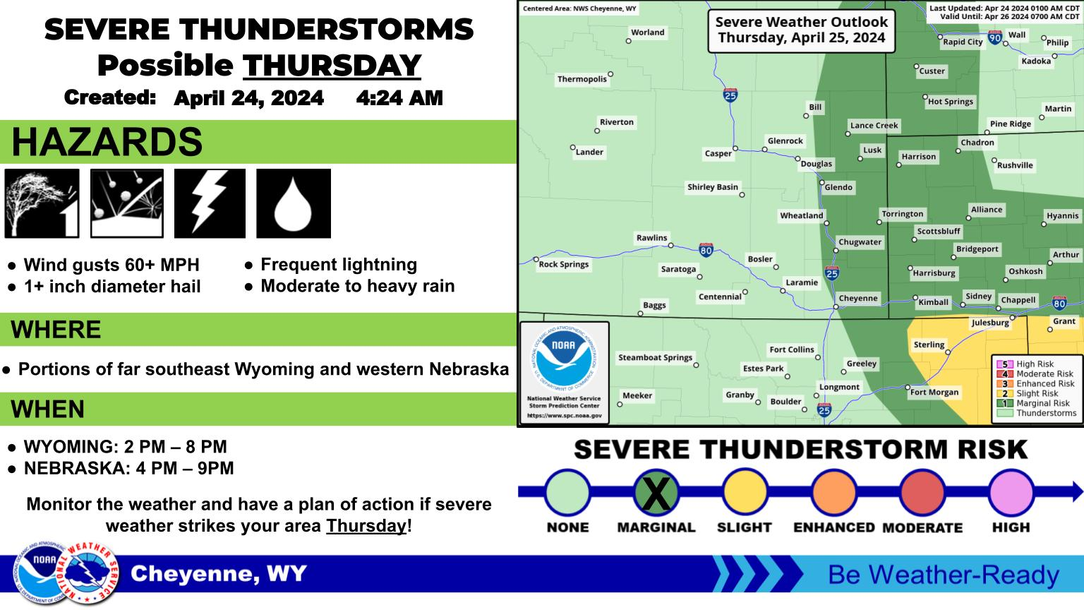
The agency posted the following on its website: Showers and thunderstorms returning to the forecast for southeast Wyoming and Nebraska Panhandle Thursday and especially Friday. For Thursday, best chances for storms look to be along and just east of the Laramie Range. Overall, the better chances for severe storms Thursday, look to be south of our forecast area. Better chances for more widespread showers and storms Friday afternoon/evening. A Marginal Risk for severe thunderstorms covers the entire Nebraska Panhandle into the southeast Wyoming plains, with a Slight Risk for extreme eastern Cheyenne County in the Panhandle. Some concerns with these risk areas shifting west to cover more of our area. Stay tuned to later updates in the next 24-36 hours on Friday as Friday could be very active.

KGAB logo
Get our free mobile app

 Forecast For The Next Three Days

The three-day forecast for southeast Wyoming and Nebraska Panhandle calls for increasing chances for showers and storms. For Thursday, a cold front begins to move into the area from the northeast. Best chances for showers and storms initially will be along the Laramie Range as the front moves in. But then chances increase for the Panhandle Thursday evening. Best chances for showers and storms will be Friday afternoon and evening as the front stall across the southeast Wyoming plains. Severe storms could be widespread Friday across the Nebraska Panhandle, with large hail, damaging downburst winds and slow moving storms that could produce heavy rainfall. Front finally shifts east Saturday, with drier air returning

Cheyenne, Laramie Forecast

Cheyenne Forecast:

Today
A 40 percent chance of showers and thunderstorms after noon. Mostly sunny, with a high near 82. Northwest wind 10 to 15 mph becoming east southeast in the afternoon.
Tonight
A 20 percent chance of showers and thunderstorms before midnight. Partly cloudy, with a low around 54. East southeast wind 10 to 15 mph becoming south after midnight.
Friday
Showers and thunderstorms likely after noon. Mostly cloudy, with a high near 80. South southwest wind 10 to 15 mph. Chance of precipitation is 60%.
Friday Night
Showers and thunderstorms likely before midnight. Mostly cloudy, with a low around 55. South wind 10 to 15 mph becoming west after midnight. Chance of precipitation is 60%.
Saturday
A 20 percent chance of showers and thunderstorms after noon. Mostly sunny, with a high near 87. West northwest wind 10 to 15 mph.
Saturday Night
Mostly clear, with a low around 54.
Sunday
Sunny, with a high near 84. Breezy.
Sunday Night
A slight chance of showers and thunderstorms before midnight. Partly cloudy, with a low around 52. Breezy.
Monday
A slight chance of showers and thunderstorms after noon. Mostly sunny, with a high near 79. Breezy.
Monday Night
A slight chance of showers before midnight. Partly cloudy, with a low around 49. Breezy.
Tuesday
A slight chance of showers and thunderstorms. Sunny, with a high near 77. Breezy.
Tuesday Night
A slight chance of showers and thunderstorms. Mostly cloudy, with a low around 47.
Juneteenth
A slight chance of showers and thunderstorms. Mostly sunny, with a high near 73. Breezy.
Laramie Forecast
Today
A 40 percent chance of showers and thunderstorms, mainly after 3pm. Sunny, with a high near 85. South wind 5 to 15 mph becoming north northwest in the afternoon.
Tonight
A 20 percent chance of showers and thunderstorms before midnight. Partly cloudy, with a low around 55. Breezy, with an east southeast wind 10 to 20 mph becoming south after midnight.
Friday
A 40 percent chance of showers and thunderstorms after noon. Mostly cloudy, with a high near 79. Southwest wind 10 to 15 mph.
Friday Night
A 50 percent chance of showers and thunderstorms before midnight. Mostly cloudy, with a low around 51. West southwest wind 5 to 10 mph.
Saturday
A 20 percent chance of showers and thunderstorms after noon. Sunny, with a high near 83. West southwest wind 5 to 15 mph, with gusts as high as 25 mph.
Saturday Night
Mostly clear, with a low around 51.
Sunday
Sunny, with a high near 84. Breezy.
Sunday Night
Partly cloudy, with a low around 52.
Monday
Sunny, with a high near 79. Breezy.
Monday Night
Mostly clear, with a low around 48. Breezy.
Tuesday
A slight chance of showers and thunderstorms. Sunny, with a high near 73.
Tuesday Night
A slight chance of showers. Partly cloudy, with a low around 46.
Juneteenth
A slight chance of showers and thunderstorms. Mostly sunny, with a high near 71.

Octane Associates - Drag Racing

Gallery Credit: Ashley Anton

More From KGAB