The Cheyenne Office of the National Weather Service reports a wind gust of 90 miles per hour was recorded in the South Greeley area of Cheyenne on Saturday. The agency posted the following on its website:

Yes, that 90mph wind gust in the vicinity of Cheyenne is real. We had a report off of HWY 85 near South Greeley, WY earlier this afternoon to verify it.

May be an image of text

The agency also posted a timeline of hazards for southeast Wyoming and the Nebraska Panhandle:

As this complex system continues, here is a look at the headlines through Sunday night into early Monday morning. In areas that receive significant snowfall, impacts will linger over the next few days. Across most areas, conditions will begin improving by Sunday afternoon to evening. For the latest forecast, go to weather.gov/cys #wywx #newx For all road information, refer to WYDOT at wyoroad.info or NDOT at 511.nebraska.gov or dial 5-1-1 #wyoroad

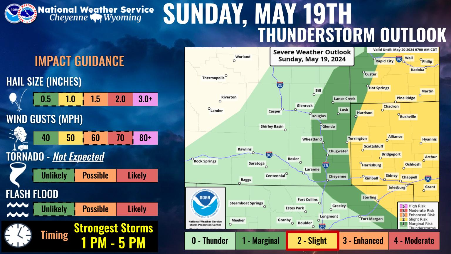
Aaron Woodward with the Cheyenne Office of the National Weather Service told Townsquare Media that as of Sunday morning in the Cheyenne area, reports of damage from the wind were trickling in. Most of the reports were of tree limbs breaking off and that sort of thing, but he also noted that because it's Sunday morning, the reports may be coming in more slowly than would normally be the case.

KGAB logo
Get our free mobile app

Forecast for Cheyenne and Laramie:

Today
A 20 percent chance of snow before 10am. Partly sunny, with a high near 45. Windy, with a west northwest wind 40 to 45 mph decreasing to 35 to 40 mph in the afternoon. Winds could gust as high as 70 mph.
Tonight
Mostly clear, with a low around 27. Windy, with a west northwest wind 25 to 30 mph decreasing to 15 to 20 mph after midnight. Winds could gust as high as 45 mph.
Monday
A 20 percent chance of snow after 1pm. Mostly sunny, with a high near 49. Breezy, with a west wind 15 to 20 mph, with gusts as high as 30 mph.
Monday Night
A 20 percent chance of snow before 7pm. Partly cloudy, with a low around 26. West wind 10 to 15 mph decreasing to 5 to 10 mph after midnight. Winds could gust as high as 30 mph.
Tuesday
Sunny, with a high near 56. West wind 10 to 15 mph.
Tuesday Night
Mostly cloudy, with a low around 33.
Wednesday
A slight chance of snow before 9am, then a slight chance of rain and snow between 9am and 1pm, then a chance of rain after 1pm. Partly sunny, with a high near 50. Breezy. Chance of precipitation is 30%.
Wednesday Night
A chance of rain before 7pm. Partly cloudy, with a low around 27. Blustery.
Thursday
Sunny, with a high near 58.
Thursday Night
Mostly clear, with a low around 35.
Friday
Sunny, with a high near 68.
Friday Night
Partly cloudy, with a low around 42.
Saturday
A slight chance of rain. Mostly sunny, with a high near 65. Breezy.
 
Forecast for Laramie:
Today
A 20 percent chance of snow before 9am. Mostly sunny, with a high near 39. Windy, with a west wind 30 to 40 mph, with gusts as high as 60 mph.
Tonight
Partly cloudy, with a low around 21. Blustery, with a west wind 20 to 25 mph decreasing to 15 to 20 mph after midnight. Winds could gust as high as 35 mph.
Monday
A 20 percent chance of snow after noon. Mostly sunny, with a high near 44. Breezy, with a west northwest wind 15 to 20 mph, with gusts as high as 30 mph.
Monday Night
Partly cloudy, with a low around 22. Northwest wind 5 to 15 mph becoming south southwest in the evening.
Tuesday
Sunny, with a high near 50. South southwest wind 5 to 15 mph becoming west northwest in the afternoon.
Tuesday Night
Mostly cloudy, with a low around 28. Blustery.
Wednesday
A 20 percent chance of snow. Mostly sunny, with a high near 48. Breezy.
Wednesday Night
Partly cloudy, with a low around 25.
Thursday
Sunny, with a high near 55.
Thursday Night
Mostly clear, with a low around 32.
Friday
Sunny, with a high near 65. Breezy.
Friday Night
Partly cloudy, with a low around 36. Breezy.
Saturday
A slight chance of rain. Mostly sunny, with a high near 60. Breezy.

'Yellowstone' Television Series Now Has Food Products in Wyoming Stores

Gallery Credit: Walmart.com

More From KGAB