Southeast Wyoming's weather outlook includes a little bit of everything this week, including a strong cold front this evening and the potential for a arctic front towards the weekend.

That's according to the Cheyenne Office of the National Weather Service. The agency posted the following on it's website:

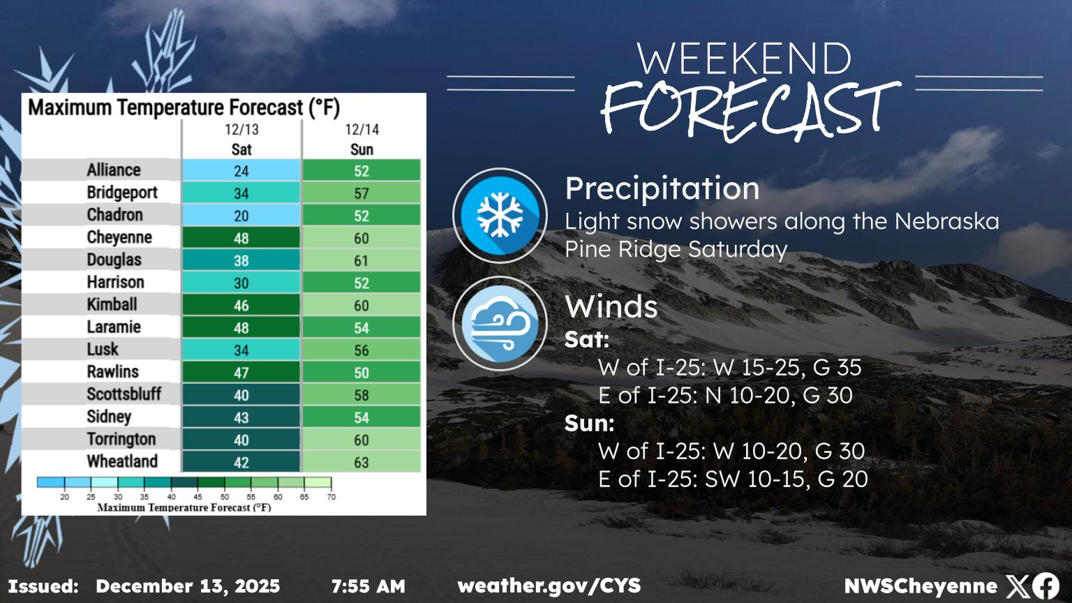
 A dynamic week of weather is expected for the week ahead. After one more mild and windy day Monday, a strong cold front will move through Monday night. Expect a cold and windy day Tuesday! Temperatures will moderate in between systems Wednesday through Friday (although a few snow showers will be possible Wednesday night). Windy conditions may continue for the southeast Wyoming wind prone areas. We are watching the potential for an arctic cold front which would arrive Saturday or Sunday. This would bring much colder temperatures and a chance for widespread light to moderate snowfall. Stay tuned for more details in the coming days as this may impact travel conditions on the tail end of the holiday weekend.

In the meantime, high wind warnings and watches have been posted for some areas through Tuesday morning, with winds gusting up to 65-70 mph possible:

- A High Wind Watch has been issued for the northern Nebraska Panhandle from 8PM tonight through 2PM Tuesday. Wind gusts up to 60 mph are possible. The High Wind Warnings for southeast Wyoming remain in effect through the morning Tuesday. Use caution if traveling with light weight or high profile vehicles, including campers.


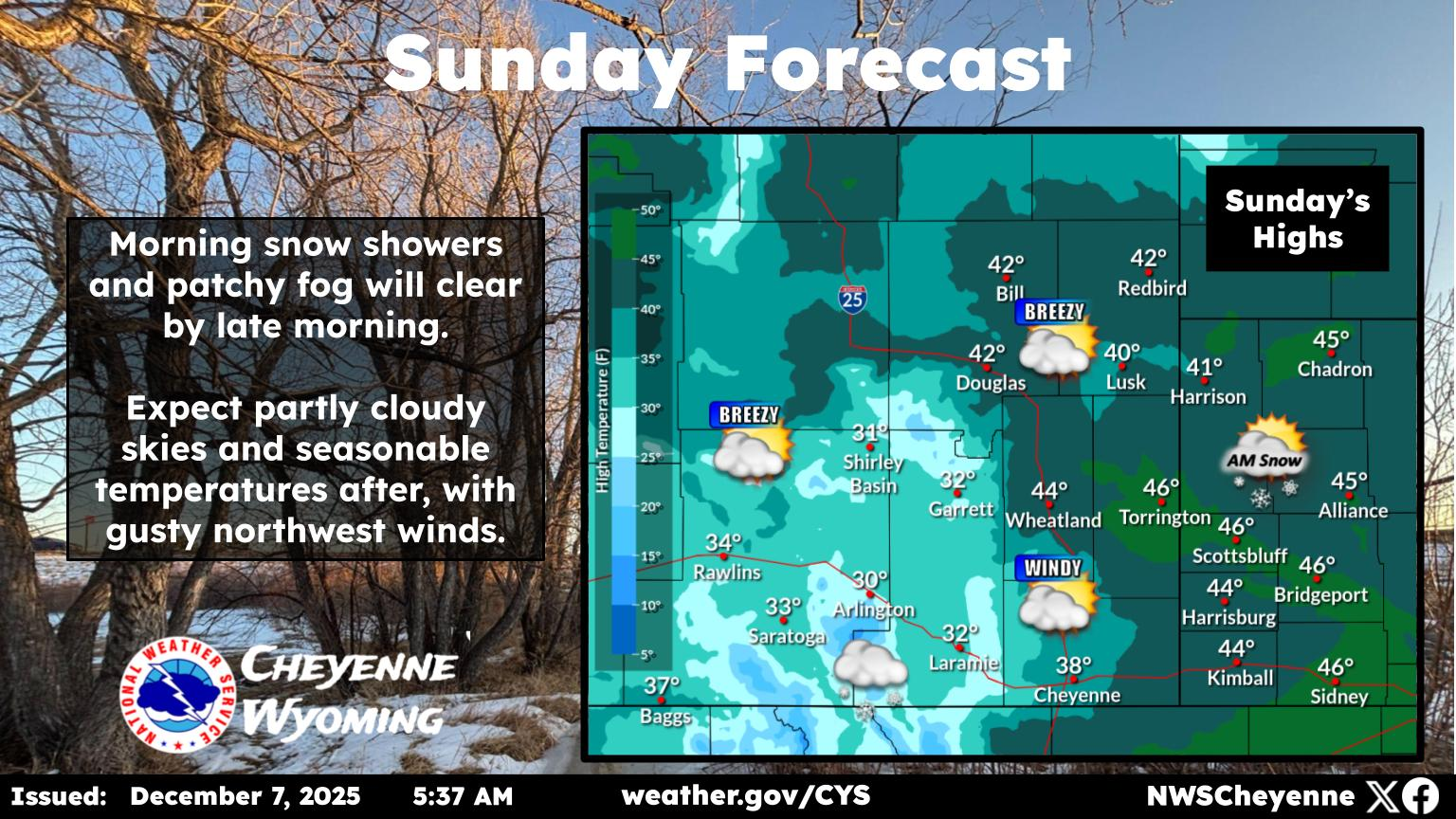
Cheyenne, Laramie Forecasts

Cheyenne Forecast:

Today
Mostly sunny, with a high near 53. Breezy, with a west wind 15 to 20 mph, with gusts as high as 30 mph.
Tonight
Mostly clear, with a low around 22. Windy, with a northwest wind 25 to 30 mph decreasing to 20 to 25 mph after midnight. Winds could gust as high as 45 mph.
Tuesday
Sunny, with a high near 34. Windy, with a northwest wind 25 to 30 mph decreasing to 15 to 20 mph in the afternoon. Winds could gust as high as 40 mph.
Tuesday Night
Partly cloudy, with a low around 13. North wind 5 to 10 mph becoming southwest in the evening.
Wednesday
Partly sunny, with a high near 45. West northwest wind 5 to 15 mph.
Wednesday Night
Mostly cloudy, with a low around 25.
Thanksgiving Day
Mostly sunny, with a high near 48.
Thursday Night
Partly cloudy, with a low around 25.
Friday
Mostly sunny, with a high near 50.
Friday Night
A chance of snow showers, mainly after 11pm. Mostly cloudy, with a low around 15.
Saturday
A chance of snow showers. Mostly cloudy, with a high near 26.
Saturday Night
A chance of snow showers. Mostly cloudy, with a low around 5.
Sunday
A chance of snow showers. Mostly cloudy, with a high near 18.
Laramie Forecast
Today
Mostly sunny, with a high near 46. Breezy, with a west wind 15 to 20 mph increasing to 20 to 25 mph in the afternoon. Winds could gust as high as 40 mph.
Tonight
Mostly clear, with a low around 19. Breezy, with a west wind 20 to 25 mph, with gusts as high as 40 mph.
Tuesday
Sunny, with a high near 30. Blustery, with a northwest wind 15 to 25 mph, with gusts as high as 35 mph.
Tuesday Night
Partly cloudy, with a low around 16. West southwest wind 5 to 15 mph.
Wednesday
Partly sunny, with a high near 40. Breezy, with a west wind 10 to 15 mph increasing to 15 to 20 mph in the afternoon. Winds could gust as high as 30 mph.
Wednesday Night
Partly cloudy, with a low around 28.
Thanksgiving Day
Mostly sunny, with a high near 48.
Thursday Night
Partly cloudy, with a low around 28.
Friday
A slight chance of snow showers after 11am. Mostly sunny, with a high near 45.
Friday Night
A chance of snow showers. Mostly cloudy, with a low around 17.
Saturday
A chance of snow showers. Mostly cloudy, with a high near 27.
Saturday Night
A chance of snow showers. Mostly cloudy, with a low around 5.
Sunday
A chance of snow showers. Mostly cloudy, with a high near 17.

More From KGAB