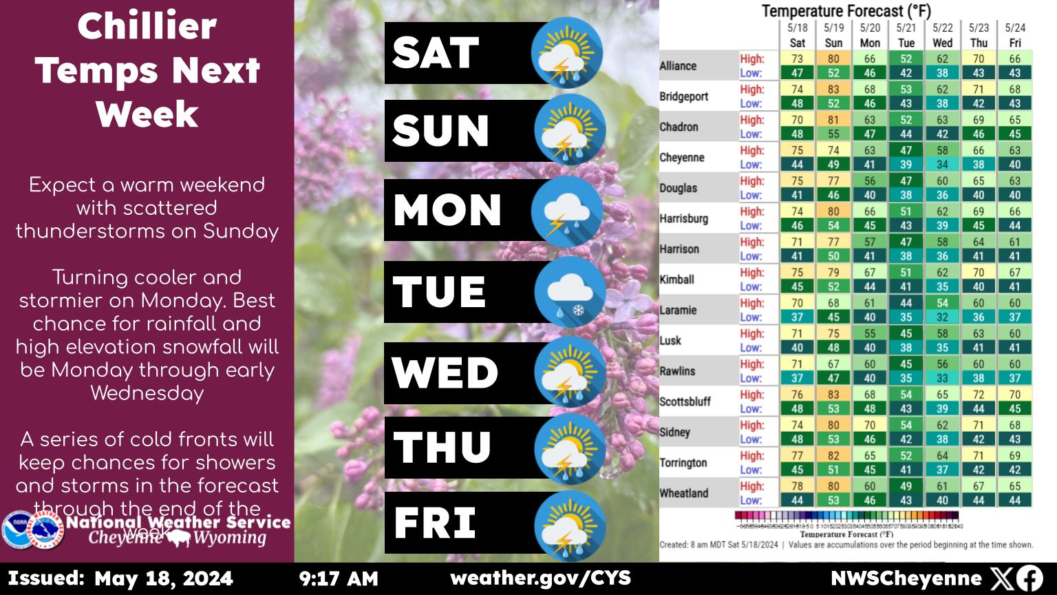
The Cheyenne Office of the National Weather Service says we can expect more cool, wet weather in southeast Wyoming over the next few days.

The agency posted this statement and graphic on it's website:

Well, the next week will continue this cool and wet weather with near daily chances for precipitation across southeast Wyoming and the Nebraska panhandle. The best day for the most widespread showers and isolated thunderstorms will be Sunday! For the latest forecast or if your city isn’t mentioned in this graphic, go to weather.gov/cys

Here is the outlook for Saturday, May 13:

May 13th Morning Update: Cool temperatures and unsettled weather will continue today with high temperatures 10 to 15 degrees below average for this time of the year. Shower activity will increase in coverage this afternoon and this evening with a few rumbles of thunder possible. Patchy fog possible tonight.

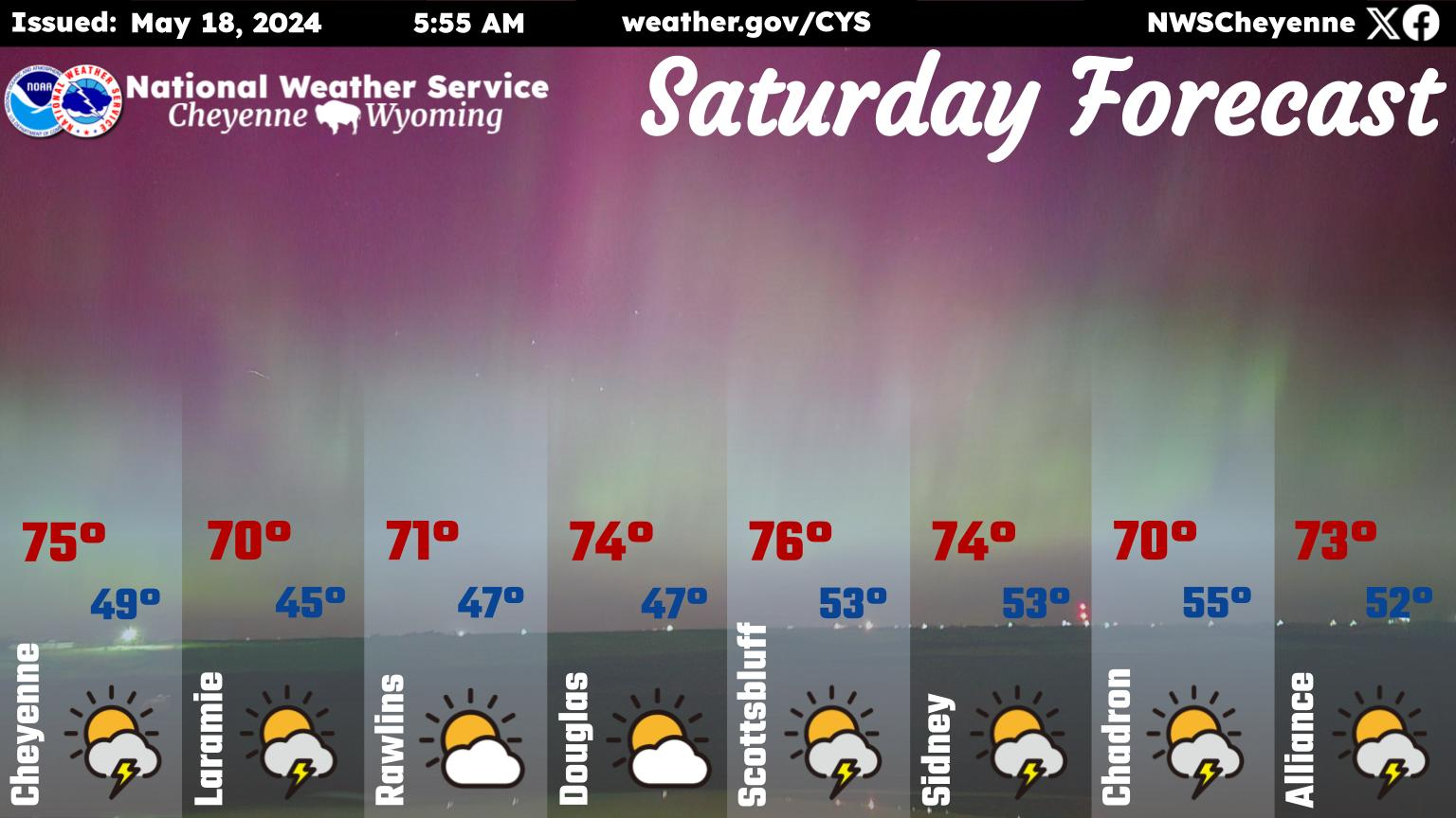
Here is the forecast for Cheyenne:

Today
A 20 percent chance of rain after noon. Mostly cloudy, with a high near 54. Breezy, with a north northwest wind around 20 mph, with gusts as high as 30 mph.
Tonight
A 50 percent chance of rain. Mostly cloudy, with a low around 43. Breezy, with a north wind 15 to 20 mph.
Sunday
Rain likely, with thunderstorms also possible after noon. Cloudy, with a high near 53. Northeast wind 10 to 15 mph. Chance of precipitation is 70%.
Sunday Night
Rain likely and possibly a thunderstorm. Mostly cloudy, with a low around 44. Northeast wind 5 to 15 mph becoming southeast after midnight. Chance of precipitation is 70%.
Monday
A chance of showers, with thunderstorms also possible after noon. Mostly cloudy, with a high near 61. South wind 5 to 15 mph. Chance of precipitation is 50%.
Monday Night
Partly cloudy, with a low around 46.
Tuesday
A 30 percent chance of showers and thunderstorms after noon. Sunny, with a high near 73.
Tuesday Night
A slight chance of showers and thunderstorms before midnight. Partly cloudy, with a low around 47.
Wednesday
A chance of showers and thunderstorms after noon. Mostly sunny, with a high near 71.
Wednesday Night
A chance of showers and thunderstorms before midnight. Partly cloudy, with a low around 48.
Thursday
Showers likely and possibly a thunderstorm. Partly sunny, with a high near 69.
Thursday Night
A chance of showers and thunderstorms. Mostly cloudy, with a low around 44.
Friday
A chance of showers and thunderstorms. Partly sunny, with a high near 65.
Here is the forecast for Laramie:
Today
A 40 percent chance of rain after noon. Mostly cloudy, with a high near 44. Breezy, with a north wind 15 to 20 mph.
Tonight
A 50 percent chance of rain. Cloudy, with a low around 37. North wind 10 to 15 mph.
Sunday
Rain, with thunderstorms also possible after noon. High near 45. East northeast wind 10 to 15 mph. Chance of precipitation is 80%.
Sunday Night
Rain likely and possibly a thunderstorm. Cloudy, with a low around 41. East southeast wind 5 to 15 mph. Chance of precipitation is 70%.
Monday
A chance of showers, then showers likely and possibly a thunderstorm after noon. Partly sunny, with a high near 59. Southeast wind 5 to 15 mph becoming southwest in the afternoon. Chance of precipitation is 60%.
Monday Night
Partly cloudy, with a low around 43.
Tuesday
A 40 percent chance of showers and thunderstorms after noon. Sunny, with a high near 65. Breezy.
Tuesday Night
A slight chance of showers and thunderstorms before midnight. Partly cloudy, with a low around 43. Breezy.
Wednesday
A chance of showers and thunderstorms after noon. Mostly sunny, with a high near 64.
Wednesday Night
A chance of showers and thunderstorms before midnight. Partly cloudy, with a low around 43.
Thursday
Showers likely and possibly a thunderstorm. Mostly sunny, with a high near 62.
Thursday Night
A chance of showers and thunderstorms. Mostly cloudy, with a low around 41.
Friday
A chance of showers and thunderstorms. Partly sunny, with a high near 59.

The Ten Most Tornado-Prone Counties in America

When it comes to the topic of tornadoes, Oklahoma is universally known around the world for producing some of the biggest, including the last F6 ever measured... but it'd probably surprise most Okies that the Sooner State doesn't even crack the top five of the most tornado-prone counties in America.

More From KGAB