The Cheyenne Office of the National Weather Service says heavy rain, large hail and damaging winds are possible in some areas of SE Wyoming through Thursday.

A few tornadoes may be possible on Wednesday

Here is the latest updated forecast from the agency for the rest of today [May 9]:

Key Points: ● Isolated strong to severe thunderstorms in the late afternoon

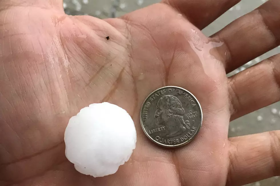
● Large hail up to size of golf balls, 60-70 mph winds, will be the primary threats.

● Additional thunderstorms are possible overnight posing a large hail threat, focused only in far southeast Wyoming and in southwest Nebraska.

Timing: ● 4pm to 9pm this evening for the first round.

Here are the key points for Wednesday according to the National Weather Service:

Key Points:

- Strong to severe thunderstorms are likely over much of southeast Wyoming and west Nebraska.

● Large hail up to size of golf balls, 60-70 mph winds and heavy rain will be the primary threats.

● A few tornadoes are also possible, especially farther south toward the Colorado border. Timing:

● Storms will begin over WY mountains as early as 2pm and shift east over WY High Plains through the afternoon.

● The strongest cells will likely peak in intensity in the 4pm to 8pm timeframe, along and east of I-25 and in the Nebraska Panhandle.

Here is the timeline for the severe weather:

Here is the Cheyenne forecast:

This Afternoon
A 30 percent chance of showers and thunderstorms, mainly after 3pm. Mostly sunny, with a high near 73. East southeast wind 10 to 15 mph.
Tonight
A chance of showers and thunderstorms between midnight and 3am, then a slight chance of showers. Patchy fog after 5am. Otherwise, mostly cloudy, with a low around 47. East southeast wind 5 to 15 mph. Chance of precipitation is 50%.
Wednesday
Showers likely and possibly a thunderstorm after noon. Some of the storms could be severe. Patchy fog before 8am. Otherwise, partly sunny, with a high near 69. Southeast wind 5 to 15 mph. Chance of precipitation is 60%.
Wednesday Night
Showers and possibly a thunderstorm. Low around 46. Southeast wind 10 to 15 mph becoming east northeast after midnight. Chance of precipitation is 90%.
Thursday
Rain and possibly a thunderstorm. High near 59. Breezy, with a northeast wind 10 to 15 mph becoming north northwest 20 to 25 mph in the afternoon. Winds could gust as high as 35 mph. Chance of precipitation is 90%.
Thursday Night
Rain and possibly a thunderstorm. Low around 43. Windy. Chance of precipitation is 80%.
Friday
A chance of rain, then rain likely and possibly a thunderstorm after noon. Mostly cloudy, with a high near 56. Breezy. Chance of precipitation is 60%.
Friday Night
A chance of rain, mainly before midnight. Mostly cloudy, with a low around 43. Breezy.
Saturday
A chance of rain and thunderstorms after noon. Partly sunny, with a high near 57. Breezy.
Saturday Night
A chance of rain. Mostly cloudy, with a low around 42. Breezy.
Sunday
A chance of rain and thunderstorms. Partly sunny, with a high near 58.
Sunday Night
A slight chance of rain. Partly cloudy, with a low around 40.
Monday
A slight chance of rain and thunderstorms. Mostly sunny, with a high near 66.
Here is the Laramie forecast:
This Afternoon
A 40 percent chance of showers and thunderstorms, mainly after 3pm. Partly sunny, with a high near 61. Southwest wind around 15 mph.
Tonight
A 30 percent chance of showers and thunderstorms, mainly before 9pm. Partly cloudy, with a low around 42. West southwest wind 10 to 15 mph becoming south southeast in the evening.
Wednesday
Showers likely and possibly a thunderstorm after noon. Some of the storms could be severe. Partly sunny, with a high near 60. Breezy, with a southeast wind 10 to 15 mph increasing to 15 to 20 mph in the afternoon. Winds could gust as high as 30 mph. Chance of precipitation is 70%.
Wednesday Night
Showers and possibly a thunderstorm. Low around 42. Breezy, with a southeast wind 15 to 20 mph becoming northwest after midnight. Winds could gust as high as 30 mph. Chance of precipitation is 90%.
Thursday
Rain and possibly a thunderstorm. High near 47. Breezy, with a north wind 15 to 25 mph, with gusts as high as 30 mph. Chance of precipitation is 90%.
Thursday Night
Rain and possibly a thunderstorm. Low around 37. Breezy. Chance of precipitation is 80%.
Friday
Rain likely, then rain and possibly a thunderstorm after noon. High near 44. Breezy. Chance of precipitation is 80%.
Friday Night
A chance of rain, mainly before midnight. Mostly cloudy, with a low around 37. Breezy.
Saturday
A slight chance of rain, then a chance of rain and thunderstorms after noon. Mostly cloudy, with a high near 46.
Saturday Night
A chance of rain. Mostly cloudy, with a low around 38.
Sunday
A chance of rain and thunderstorms. Mostly cloudy, with a high near 47.
Sunday Night
A slight chance of rain. Mostly cloudy, with a low around 37.
Monday
A chance of rain and thunderstorms. Mostly sunny, with a high near 58.

2022's Deadliest Wyoming County by Traffic Deaths

While car crashes can occur anywhere, some roads in Wyoming are more dangerous than others.

According to Wyoming Highway Patrol data, there were 117 fatal crashes in the Cowboy State in 2022 resulting in 133 deaths.

Of those fatal crashes, the majority (13.68%) occurred in Laramie County -- two in January, one in February, one in March, two in April, one in June, two in July, three in August, two in September, one in November, and one in December.

Sweetwater County saw the second most fatal crashes last year, 12, while Fremont and Lincoln counties each saw 10.

Albany and Park counties each recorded eight, and Campbell, Converse, and Natrona counties each tallied seven.

The deadliest 2022 crash in Laramie County took place on June 17 when two semis collided on Interstate 80 east of Cheyenne and immediately became engulfed in flames killing both drivers and a passenger.


Laramie County also saw two fatal crashes involving motorcyclists, two fatal crashes involving juveniles, and a fatal crash involving a pedestrian last year.

Below is the Wyoming Highway Patrol narrative of every fatal crash that occurred in Laramie County in 2022.

More From KGAB