Southeast Wyoming can expect snow and colder weather today [March 1], followed by unsettled weather over the next few days, according to the Cheyenne Office of the National Weather Service.

The agency posted the following on its website:

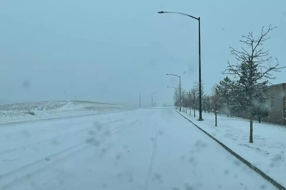
9:15 PM February 28th - Colder weather and snow showers are expected Wednesday across the region. Temperatures will be mostly in the 20s and 30s Wednesday afternoon with mostly cloudy skies. Snow showers will move into the area mid-morning Wednesday and will continue into the afternoon hours. Minimal accumulations are expected east of I-25. Farther west, up to 2 inches will be possible across lower elevations including Rawlins, while higher amounts will be possible in the mountains. Use caution if out traveling Wednesday, especially between Cheyenne and Rawlins.

Here is the forecast for the next few days:

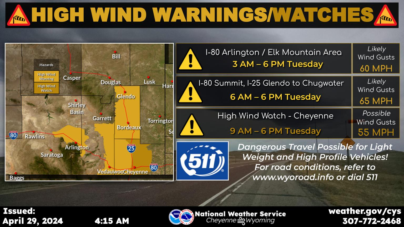
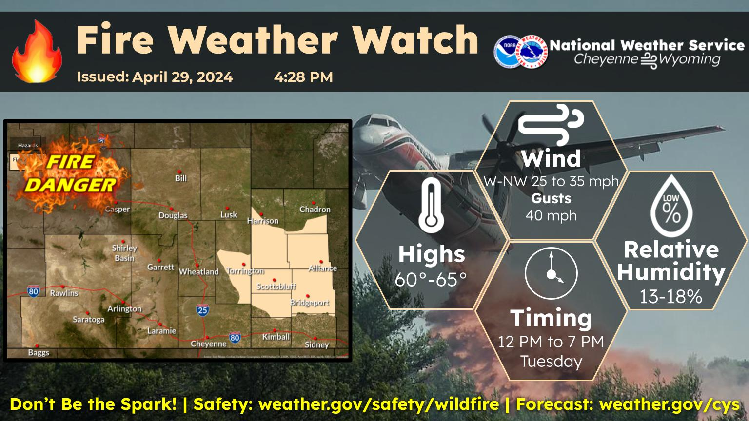
An unsettled extended weather forecast for southeast Wyoming and Nebraska Panhandle in store. After a fairly nice start Thursday, it looks like we could see another high wind event for the wind prone areas by the evening. These strong winds could impact travel for light weight and high profile vehicles. A cold front moves through Friday that will bring fairly widespread light snow mainly to southeast Wyoming. A more widespread snow event looks to be taking shape for Monday through Wednesday next week, as a series of disturbances move through the area. Keep an eye on the forecast as we move into Monday next week, as some forecast guidance showing the possibility of significant snowfall, Tuesday afternoon through Wednesday afternoon. Stay tuned!


Here is the forecast for Cheyenne:

Today
A 30 percent chance of snow, mainly after 5pm. Increasing clouds, with a high near 31. Breezy, with a south southeast wind 5 to 10 mph becoming south southeast 15 to 20 mph in the morning. Winds could gust as high as 30 mph.
Tonight
A 30 percent chance of snow, mainly before 8pm. Mostly cloudy, with a low around 17. South southeast wind 5 to 15 mph becoming west after midnight.
Thursday
Sunny, with a high near 37. North northwest wind 5 to 15 mph.
Thursday Night
Partly cloudy, with a low around 21. Blustery, with a west wind 15 to 20 mph, with gusts as high as 30 mph.
Friday
A 20 percent chance of snow after 11am. Partly sunny, with a high near 37. Windy, with a west northwest wind 25 to 30 mph, with gusts as high as 40 mph.
Friday Night
A 30 percent chance of snow before 11pm. Partly cloudy, with a low around 14. Windy.
Saturday
Mostly sunny, with a high near 33. Breezy.
Saturday Night
Mostly cloudy, with a low around 20. Breezy.
Sunday
Mostly sunny, with a high near 43. Breezy.
Sunday Night
A chance of snow, mainly before 11pm. Mostly cloudy, with a low around 21. Blustery.
Monday
A chance of snow. Partly sunny, with a high near 37.
Monday Night
A chance of snow. Mostly cloudy, with a low around 20.
Tuesday
A chance of snow. Mostly cloudy, with a high near 31. Breezy.
Here is the Laramie Forecast:
Today
A 40 percent chance of snow after 11am. Increasing clouds, with a high near 24. Wind chill values between -5 and 5. Breezy, with a south wind 10 to 15 mph becoming south southeast 20 to 25 mph in the morning.
Tonight
A 30 percent chance of snow, mainly before 8pm. Mostly cloudy, then gradually becoming mostly clear, with a low around 11. Breezy, with a south wind 15 to 20 mph becoming west 10 to 15 mph after midnight.
Thursday
Mostly sunny, with a high near 25. Wind chill values between -5 and 5. Blustery, with a west northwest wind 10 to 15 mph increasing to 15 to 20 mph in the afternoon. Winds could gust as high as 30 mph.
Thursday Night
Partly cloudy, with a low around 15. Wind chill values between zero and 5. Breezy, with a west wind 15 to 25 mph, with gusts as high as 35 mph.
Friday
A 40 percent chance of snow after 11am. Partly sunny, with a high near 26. Windy, with a west wind 20 to 25 mph increasing to 25 to 30 mph in the afternoon. Winds could gust as high as 45 mph.
Friday Night
A 30 percent chance of snow before 11pm. Partly cloudy, with a low around 5. Windy.
Saturday
Mostly sunny, with a high near 30. Breezy.
Saturday Night
A slight chance of snow after 11pm. Mostly cloudy, with a low around 17. Breezy.
Sunday
A chance of snow, mainly after 11am. Partly sunny, with a high near 29. Breezy.
Sunday Night
A chance of snow. Mostly cloudy, with a low around 18.
Monday
A chance of snow. Mostly cloudy, with a high near 31.
Monday Night
A chance of snow. Mostly cloudy, with a low around 16.
Tuesday
A chance of snow. Patchy blowing snow. Mostly cloudy, with a high near 26. Breezy.

The Best Country Singer From Every State

Some states, like Oklahoma and Texas, are loaded with famous country singers. Others, like Nevada and Maine, are still looking for a real breakthrough artist. See the best and most successful country music artist from all 50 states, starting with Hank Williams and Alabama.

More From KGAB