The Cheyenne Office of the National Weather Service says there is a marginal risk of strong to severe thundershowers on Wednesday, with the highest risk of severe storms east of Interstate 25.

The agency posted the following on its website:

A Marginal Risk is in effect Wednesday for the potential for severe thunderstorms. Expect multiple waves of scattered strong to severe thunderstorms starting around noon, and continuing through the afternoon and overnight. Primary threat will be strong wind gusts, lightning, moderate to heavy rainfall, and small hail.


\
Scattered showers and thunderstorms are expected Wednesday afternoon and evening. A few isolated strong to severe storms are possible, but mainly east of Interstate-25.

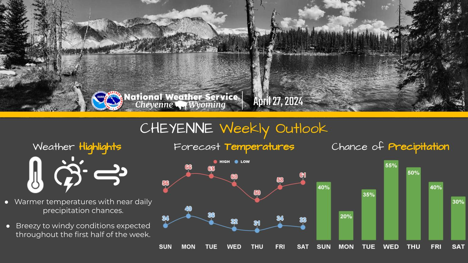
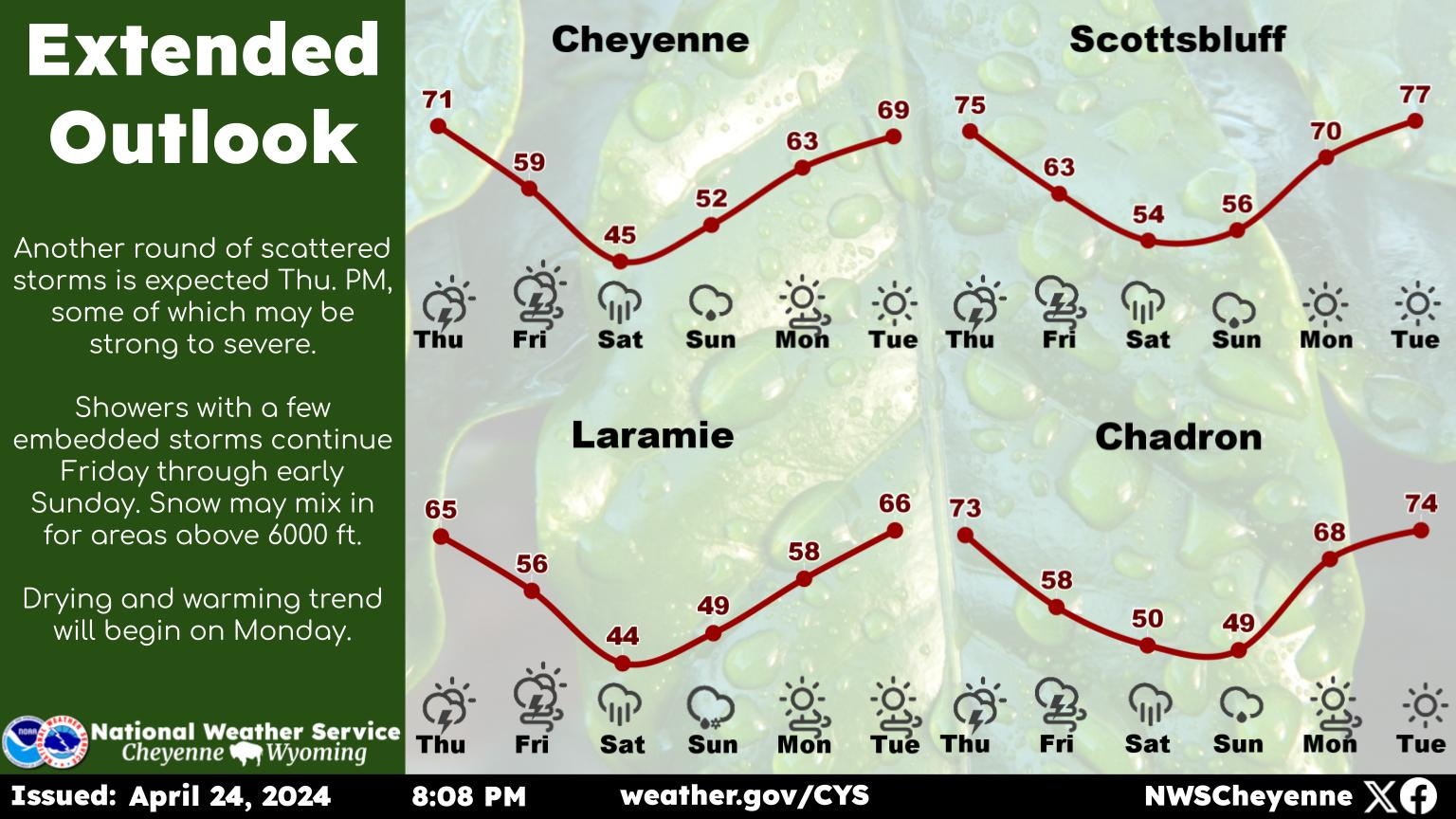
Here is the forecast for Cheyenne:

Today
Scattered showers and thunderstorms after noon. Mostly sunny, with a high near 72. Northwest wind 5 to 10 mph. Chance of precipitation is 50%.
Tonight
Showers likely and possibly a thunderstorm before midnight, then isolated showers and thunderstorms between midnight and 3am, then a slight chance of showers after 3am. Mostly cloudy, with a low around 47. North wind around 10 mph. Chance of precipitation is 60%. New rainfall amounts of less than a tenth of an inch, except higher amounts possible in thunderstorms.
Thursday
A chance of showers, then showers likely and possibly a thunderstorm after noon. Mostly cloudy, with a high near 59. North northeast wind around 10 mph. Chance of precipitation is 70%.
Thursday Night
Showers likely and possibly a thunderstorm before midnight, then a slight chance of showers and thunderstorms between midnight and 3am, then a slight chance of showers after 3am. Mostly cloudy, with a low around 43. North northeast wind 5 to 10 mph. Chance of precipitation is 60%.
Friday
A 20 percent chance of showers and thunderstorms after noon. Mostly sunny, with a high near 63. North wind 5 to 10 mph becoming south southeast in the afternoon.
Friday Night
Partly cloudy, with a low around 43.
Saturday
Sunny, with a high near 72.
Saturday Night
Mostly clear, with a low around 46.
Sunday
A chance of showers and thunderstorms after noon. Mostly sunny, with a high near 71.
Sunday Night
Partly cloudy, with a low around 46.
Monday
A chance of showers and thunderstorms. Mostly sunny, with a high near 74.
Monday Night
A chance of showers and thunderstorms. Partly cloudy, with a low around 49.
Tuesday
A chance of showers and thunderstorms. Mostly sunny, with a high near 74.


Here is the Laramie forecast:

Today
Scattered showers and thunderstorms after noon. Mostly sunny, with a high near 67. South southwest wind 5 to 15 mph becoming northwest in the afternoon. Chance of precipitation is 40%.
Tonight
Scattered showers and thunderstorms before midnight, then isolated showers. Mostly cloudy, with a low around 43. Northwest wind 10 to 15 mph becoming east southeast after midnight. Chance of precipitation is 40%.
Thursday
A chance of showers, then showers likely and possibly a thunderstorm after noon. Mostly cloudy, with a high near 61. East northeast wind 5 to 10 mph. Chance of precipitation is 70%.
Thursday Night
A 50 percent chance of showers and thunderstorms before midnight. Mostly cloudy, with a low around 37. East northeast wind 5 to 10 mph.
Friday
A 30 percent chance of showers and thunderstorms after noon. Partly sunny, with a high near 62. Southeast wind 5 to 15 mph.
Friday Night
Partly cloudy, with a low around 41.
Saturday
Sunny, with a high near 69.
Saturday Night
Mostly clear, with a low around 42.
Sunday
A chance of showers and thunderstorms after noon. Mostly sunny, with a high near 69.
Sunday Night
Partly cloudy, with a low around 43.
Monday
A chance of showers and thunderstorms. Mostly sunny, with a high near 73.
Monday Night
A chance of showers and thunderstorms. Partly cloudy, with a low around 45.
Tuesday
A chance of showers and thunderstorms. Mostly sunny, with a high near 71.

Wyoming Game and Fish Wildlife Calendar Photo Contest 2023

More From KGAB