Cheyenne and Laramie could both see wind chills of -25 degrees over the next couple of days.

That's according to the Cheyenne Office of the National Weather Service, which posted this graphic on its website:


Here are the latest updates for minimum wind chills across southeast Wyoming and the Nebraska panhandle. Cold temperatures will be in place this weekend through next week with overnight lows in the single digits and below zero. These cold temperatures combined with gusty winds will result in wind chills highlighted above. Please limit time spent outdoors to prevent the possibility of frostbite. #WYWx #NEWx

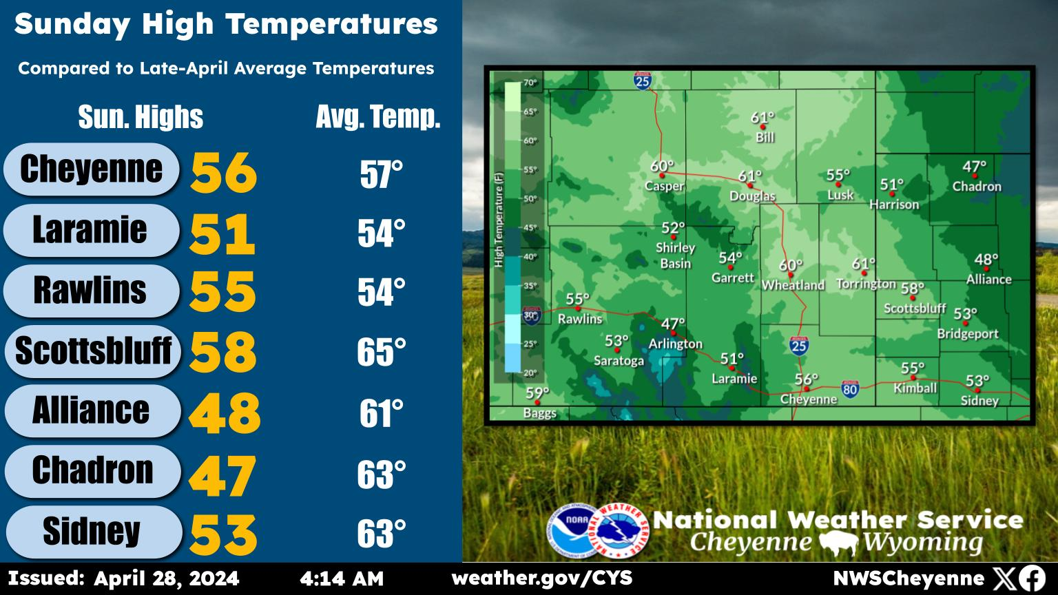
The overall southeast Wyoming forecast continues to call for brutally cold weather and snow:


A look ahead at the weather across southeast Wyoming and Nebraska Panhandle, calls for snow and really cold temperatures through Monday. This is due to a stalled out arctic boundary that's going to be laying over our western forecast zones near Rawlins. North and east of this front, it's going to get really cold! Look for single digit highs both Sunday and Monday, with overnight lows well below zero. Along with the very cold temperatures, we're looking at light snow Sunday and Monday morning, that will end from north to south Monday afternoon. Look for warmer temperatures to return Tuesday through Thursday, but with the warmer temperatures, comes increasing west winds. Could see high wind headlines Tuesday night through Wednesday morning, with a more widespread high wind event Thursday. Stay warm the next few days, protect your outdoor four legged friends and stay tuned to later updates in the forecast. We'll keep you informed!

Here is the latest Cheyenne weather forecast:

Today
Snow showers likely, mainly after 2pm. Mostly cloudy, with a temperature rising to near 22 by 11am, then falling to around 15 during the remainder of the day. Northeast wind 10 to 15 mph becoming south southwest in the afternoon. Chance of precipitation is 60%. Total daytime snow accumulation of less than one inch possible.
Tonight
Snow likely, mainly before 11pm. Mostly cloudy, with a low around -4. Wind chill values between -10 and -20. Northeast wind 5 to 15 mph becoming southeast after midnight. Chance of precipitation is 60%. New snow accumulation of less than one inch possible.
Sunday
Snow likely, mainly after 11am. Cloudy and cold, with a high near 6. Wind chill values between -10 and -20. South southeast wind around 10 mph becoming east northeast in the afternoon. Chance of precipitation is 70%. New snow accumulation of less than one inch possible.
Sunday Night
Snow. Low around -9. Wind chill values between -15 and -20. Northeast wind 5 to 10 mph becoming southeast after midnight. Chance of precipitation is 80%. New snow accumulation of around an inch possible.
Monday
A 30 percent chance of snow before 11am. Cloudy, then gradually becoming mostly sunny and cold, with a high near 9. South wind around 5 mph.
Monday Night
Mostly clear, with a low around -4.
Tuesday
Sunny, with a high near 27.
Tuesday Night
Partly cloudy, with a low around 9.
Wednesday
Partly sunny, with a high near 29.
Wednesday Night
Partly cloudy, with a low around 9.
Thursday
Sunny, with a high near 35.
Thursday Night
Mostly clear, with a low around 18.
Friday
Mostly sunny, with a high near 40.
Here is the Laramie Forecast:
Today
Snow showers likely, mainly after 11am. Mostly cloudy, with a high near 25. South southwest wind 10 to 15 mph becoming north northwest in the afternoon. Winds could gust as high as 25 mph. Chance of precipitation is 70%. Total daytime snow accumulation of less than a half inch possible.
Tonight
Snow likely, mainly before 11pm. Mostly cloudy, with a low around -1. Wind chill values between -5 and -10. East northeast wind 5 to 10 mph becoming southeast after midnight. Chance of precipitation is 70%. New snow accumulation of less than a half inch possible.
Sunday
Snow. High near 8. Wind chill values between -5 and -15. Southeast wind around 10 mph. Chance of precipitation is 90%. New snow accumulation of 1 to 2 inches possible.
Sunday Night
Snow. Low around -10. Wind chill values between -15 and -25. East wind 5 to 10 mph. Chance of precipitation is 90%. New snow accumulation of 1 to 2 inches possible.
Monday
A 40 percent chance of snow before 11am. Cloudy, then gradually becoming mostly sunny, with a high near 12. South southeast wind 5 to 10 mph becoming northwest in the afternoon.
Monday Night
Mostly clear, with a low around -6.
Tuesday
Sunny, with a high near 24.
Tuesday Night
Partly cloudy, with a low around 4.
Wednesday
Partly sunny, with a high near 26.
Wednesday Night
Partly cloudy, with a low around 5.
Thursday
Mostly sunny, with a high near 31.
Thursday Night
Partly cloudy, with a low around 14.
Friday
Mostly sunny, with a high near 35.

Strange Sights From the Oddities and Curiosities Expo in Denver

From taxidermied animals and preserved specimens in jars to beautifully handcrafted pieces of art, the expo showcased a variety of different vendors.

More From KGAB