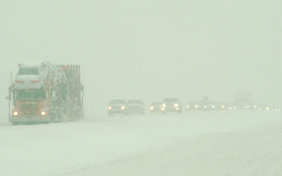
Snow Squalls to Threaten Travelers in Southeast Wyoming
Gusty winds combined with snow could make travel very difficult across portions of southeast Wyoming tonight through Thursday morning.
A High Wind Warning is in effect from 8 p.m. this evening through 8 p.m. Wednesday for the central Laramie Range, southwest Platte County, and the north Snowy Range foothills, where gusts up to 65 mph are expected.
URGENT - WEATHER MESSAGE
National Weather Service Cheyenne WY
116 PM MST Tue Feb 7 2023

WYZ106-110-081200-
/O.UPG.KCYS.HW.A.0013.230208T1000Z-230209T0300Z/
/O.NEW.KCYS.HW.W.0013.230208T0300Z-230209T0300Z/
Central Laramie Range and Southwest Platte County-
North Snowy Range Foothills-
Including the cities of Bordeaux, Arlington, and Elk Mountain
116 PM MST Tue Feb 7 2023

...HIGH WIND WARNING IN EFFECT FROM 8 PM THIS EVENING TO 8 PM MST
WEDNESDAY...

* WHAT...West winds 35 to 45 MPH with gusts up to 65 MPH expected.

* WHERE...Central Laramie Range and Southwest Platte County and
  North Snowy Range Foothills.

* WHEN...From 8 PM this evening to 8 PM MST Wednesday.

* IMPACTS...Mainly to transportation. Strong cross winds will be
  hazardous to light weight and high profile vehicles, including
  campers and tractor trailers.

PRECAUTIONARY/PREPAREDNESS ACTIONS...

A High Wind Warning means a hazardous high wind event is expected
or occurring. Sustained wind speeds of at least 40 MPH or gusts
of 58 MPH or more can lead to property damage.
A High Wind Warning is also in effect from 2 a.m. to 8 p.m. Wednesday for the south Laramie Range and foothills, where gusts up to 60 mph are expected.
URGENT - WEATHER MESSAGE
National Weather Service Cheyenne WY
116 PM MST Tue Feb 7 2023

WYZ116-117-081200-
/O.UPG.KCYS.HW.A.0013.230208T1000Z-230209T0300Z/
/O.NEW.KCYS.HW.W.0013.230208T0900Z-230209T0300Z/
South Laramie Range-South Laramie Range Foothills-
Including the cities of Buford, Pumpkin Vine, Vedauwoo, Whitaker,
Federal, and Horse Creek
116 PM MST Tue Feb 7 2023

...HIGH WIND WARNING IN EFFECT FROM 2 AM TO 8 PM MST WEDNESDAY...

* WHAT...West winds 30 to 40 MPH with gusts up to 60 MPH expected.

* WHERE...South Laramie Range and South Laramie Range Foothills.

* WHEN...From 2 AM to 8 PM MST Wednesday.

* IMPACTS...Mainly to transportation. Strong cross winds will be
  hazardous to light weight and high profile vehicles, including
  campers and tractor trailers.

PRECAUTIONARY/PREPAREDNESS ACTIONS...

A High Wind Warning means a hazardous high wind event is expected
or occurring. Sustained wind speeds of at least 40 MPH or gusts
of 58 MPH or more can lead to property damage.
In addition to the wind, the Snowy Range is expected to see 5 to 9 inches of snow between 11 a.m. Wednesday and 11 a.m. Thursday, which could significantly reduce visibility.
URGENT - WINTER WEATHER MESSAGE
National Weather Service Cheyenne WY
112 PM MST Tue Feb 7 2023

WYZ114-081200-
/O.NEW.KCYS.WW.Y.0010.230208T1800Z-230209T1800Z/
Snowy Range-
Including the cities of Centennial and Albany
112 PM MST Tue Feb 7 2023

...WINTER WEATHER ADVISORY IN EFFECT FROM 11 AM WEDNESDAY TO
11 AM MST THURSDAY...

* WHAT...Snow and blowing snow expected. Total snow accumulations
  of 5 to 9 inches. Winds gusting as high as 60 MPH.

* WHERE...Snowy Range.

* WHEN...From 11 AM Wednesday to 11 AM MST Thursday.

* IMPACTS...Travel could be very difficult. Falling and blowing
  snow could significantly reduce visibility. Wind chills as low
  as 20 degrees below zero could cause frostbite on exposed skin
  in as little as 30 minutes.

PRECAUTIONARY/PREPAREDNESS ACTIONS...

Slow down and use caution while traveling.

The latest road conditions for the state you are calling from can
be obtained by calling 5 1 1.

February 7th 3:30pm: Winter Weather Advisories and High Wind Warnings are in effect for portions of southeast Wyoming beginning tonight for the High Wind Warnings, and 11am tomorrow for winter weather advisories. Strong wind gusts up to 65MPH at times will create blowing snow and significantly reduce visibility. Know before you go! #WYWx #NEWx
The National Weather Service in Cheyenne says snow squalls will be a threat, and anyone traveling through the area should be prepared for rapidly changing conditions, potentially going from sunny skies to near whiteouts in a matter of minutes.
Travelers are encouraged to call 511 or visit wyoroad.info for the latest road conditions and closure information.

Snow showers and snow squalls, combined with widespread gusty winds, may create hazardous road travel conditions through portions of the northern and central Rockies from late tonight into Wednesday evening, February 8th. Expect rapidly changing conditions and use caution!
WYDOT Urges 'Don't Crowd the Plow!' After 105 Plows Hit in 5 Years
Gallery Credit: Joy Greenwald
More From KGAB


