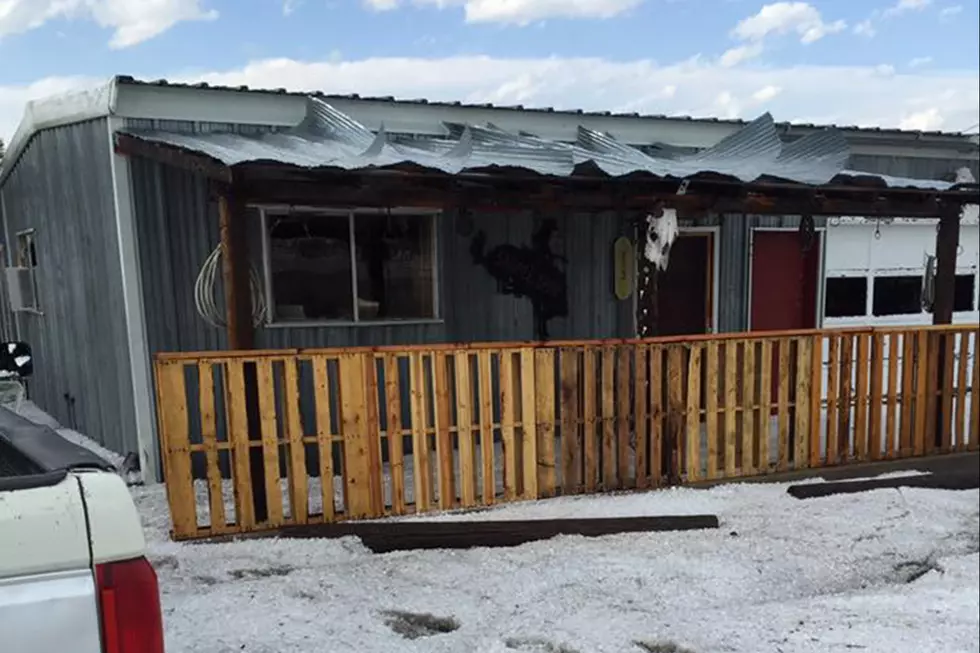
The Cheyenne Office of the National Weather Service says severe thunderstorms are possible on Friday in southeast Wyoming.

The agency says the storms could bring up to tennis-ball-size hail, winds of up to 70 miles per hour, and a few tornadoes.

The agency posted the following on its Facebook page:

"Numerous severe thunderstorms possible across southeast Wyoming and western Nebraska this afternoon with large hail and damaging winds being the primary hazard. Up to tennis ball sized hail will be possible with the strongest storms in the late afternoon while 70+ mph wind gusts will be possible headed into the evening. A few tornadoes will also be possible with thunderstorms this afternoon and evening. Be ready to take shelter indoors when storms approach and have multiple ways to receive warnings this afternoon!"

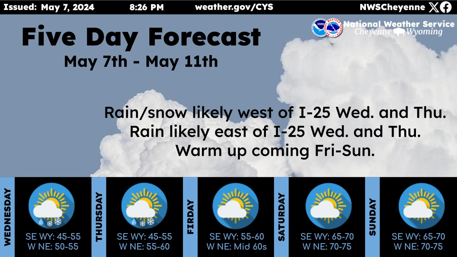
Here is the forecaast for Cheyenne:

Today
A 20 percent chance of showers and thunderstorms after 2pm. Some storms could be severe, with large hail and damaging winds. Patchy fog before 10am. Otherwise, partly sunny, with a high near 77. South wind 10 to 15 mph.
Tonight
A 20 percent chance of showers and thunderstorms before 11pm. Mostly clear, with a low around 50. Breezy, with a south wind 15 to 20 mph becoming west northwest after midnight. Winds could gust as high as 30 mph.
Saturday
Sunny, with a high near 76. Windy, with a west wind 20 to 30 mph, with gusts as high as 45 mph.
Saturday Night
Mostly clear, with a low around 47. Breezy, with a north wind 20 to 25 mph decreasing to 10 to 15 mph after midnight. Winds could gust as high as 35 mph.
Sunday
A 20 percent chance of showers and thunderstorms after noon. Sunny, with a high near 73. West northwest wind 10 to 15 mph becoming southeast in the afternoon.
Sunday Night
Mostly clear, with a low around 50.
Monday
Sunny, with a high near 79.
Monday Night
A slight chance of showers and thunderstorms before midnight. Mostly clear, with a low around 51.
Tuesday
A slight chance of showers and thunderstorms after noon. Mostly sunny, with a high near 80.
Tuesday Night
A slight chance of showers and thunderstorms before midnight. Mostly clear, with a low around 54.
Wednesday
A slight chance of showers and thunderstorms. Sunny, with a high near 80. Breezy.
Wednesday Night
A slight chance of showers and thunderstorms. Partly cloudy, with a low around 53.
Thursday
A chance of showers and thunderstorms. Sunny, with a high near 79.
Here is the Laramie forecast:
Today
A 30 percent chance of showers and thunderstorms, mainly between 2pm and 4pm. Mostly sunny, with a high near 71. Breezy, with a south southwest wind 15 to 20 mph.
Tonight
Mostly clear, with a low around 46. Windy, with a west wind 15 to 20 mph increasing to 25 to 30 mph after midnight. Winds could gust as high as 45 mph.
Saturday
Sunny, with a high near 67. Windy, with a west wind 25 to 35 mph, with gusts as high as 55 mph.
Saturday Night
Mostly clear, with a low around 43. Breezy, with a north northwest wind 15 to 25 mph decreasing to 5 to 15 mph after midnight. Winds could gust as high as 35 mph.
Sunday
A 20 percent chance of showers and thunderstorms after noon. Sunny, with a high near 68. West southwest wind 10 to 15 mph becoming northeast in the afternoon.
Sunday Night
Mostly clear, with a low around 48.
Monday
A 20 percent chance of showers and thunderstorms after noon. Sunny, with a high near 74. Breezy.
Monday Night
Mostly clear, with a low around 49. Breezy.
Tuesday
A slight chance of showers and thunderstorms after noon. Mostly sunny, with a high near 74. Breezy.
Tuesday Night
A slight chance of showers and thunderstorms before midnight. Mostly clear, with a low around 50. Breezy.
Wednesday
A slight chance of showers and thunderstorms. Sunny, with a high near 73. Breezy.
Wednesday Night
A slight chance of showers. Mostly clear, with a low around 49. Breezy.
Thursday
A chance of showers and thunderstorms. Mostly sunny, with a high near 72. Breezy.

May 24 Landspout Spirals Over Cheyenne

A landspout - a type of tornado that is "smaller and weaker than tornadoes produced by supercells" appeared within city limits on May 24, 2023, shocking residents. The spout was visible over Dell Range Blvd. In response to the spout, F.E. Warren Air Force Base issued a warning on the base urging occupants to seek shelter.

Several Cheyenne residents captured the landspout on camera. Did you see the would-be twister appear over Cheyenne?

More From KGAB